Evacuation Warnings Issued for 13th Street Bridge Closure and Low Neighborhoods
By Paso Robles Press · Thu Mar 09 2023

UPDATE (MARCH 10, 11 A.M.) — The City of Paso Robles has issued an evacuation warning for certain neighborhoods and businesses near the Salinas River and preparing for the closure of the 13th Street bridge due to rapidly rising water levels within the Salinas River.
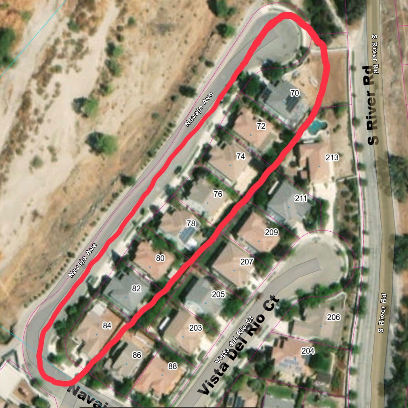
Residents close to the river in lower Navajo Avenue area and south Paso Robles Street should begin preparing to evacuate now, as the rain is forecasted to continue for the next 12 hours. Paso Robles Emergency Services staff is contacting residents of the following streets to alert them of the need to begin preparing for evacuation:
- 70 through 84 Navajo Avenue
- 406 and 390 Paso Robles Street
- 3700 and 3730 Spring Street
- 1509 through 1911 North River Road
If evacuations are necessary, an evacuation order will be issued and an evacuation shelter will be established. Residents with questions about the evacuation warning can call 805.227.7236.
Due to rapidly rising river levels, City staff is preparing to close the 13th Street bridge as soon as this afternoon. Motorists should prepare to use alternate routes. The Niblick bridge and 24th Street bridge remain open.
River Road remains closed from Navajo to 13th and from Union Road to River Oaks Drive.
ORIGINAL STORY (FRIDAY, MARCH 10)
PASO ROBLES — City officials and staff are preparing for a series of two atmospheric river storms forecasted to bring multiple inches of rain each to Paso Robles between Thursday, March 9, and Friday, March 17. Please note the following:
Storm Info:
- This storm is now looking very similar to the storm activity we witnessed on January 9 and 10.
- A flood watch is in effect from 4 p.m. Thursday, March 9 until 4 a.m. Saturday, March 11.
- Wind Gusts upwards of 50 MPH.
- Peak rainfall rates expected 8 p.m. to noon tomorrow. Could see rain rates as high as 3⁄4 to 1” per hour.
- Rainfall projections are 2-5 inches through SLO County and 5-10 inches in the NW areas of the County.
Road Closures and Safety Measures:
- River Road will be preemptively closed to through traffic from Navajo to Creston and Union to River Oaks beginning at 7 p.m. on Thursday, March 9 and will reopen when it is safe to do so. Access to businesses along N. River Road just north of Union Road will be maintained, conditions allowing.
- The City has sand available for anyone wishing to make sandbags to protect private property. Sand can be found at the City Streets Yard located at 1220 Paso Robles Street. A shovel is onsite, but please bring your own sandbags as they are not available on site. If you need sandbags, as of 7:30 p.m. on 3/9/23, they are available at: Home Depot, Kritz Excavation, Lowes, Miner’s Ace Hardware, and Steve Schmidt Topsoil.
- Police and Fire personnel are allocating significant resources to advise individuals within the Salinas riverbed to relocate to higher grounds immediately.
- Staff and equipment are in place for both storms and prepared to mobilize as conditions dictate.
Care and Shelter:
Warming centers for the unhoused will be open within Paso Robles over the next several days as follows:
- March 9: Plymouth Congregation Church (1301 Oak St) Doors open at 6 p.m. and dinner will be served
- March 10 and 11: First United Methodist Church (915 Creston Rd) o Doors open at 6 p.m. and dinner will be served
- March 13 and 14: Paso Nazarene Church (530 12th St) Doors open at 6 p.m. and dinner will be served
Prepare and Protect:
- All residents living in an area prone to flooding should have a plan in place on where you will go if you need to evacuate. Plan for your pets and any medication or items you need to bring with you.
- It is strongly advised to avoid driving through, entering, or playing in moving water at all times.
- During major storm events, public safety resources are in high demand, avoiding situations that may require an emergency response is a priority.
Residents needing to report non-emergency storm issues, such as a blocked storm drain or debris blocking safe travel on a City street, should call the non-emergency dispatch line at (805) 237-6464.
If it is an emergency, dial 9-1-1. Storm updates will be provided as necessary on PRCity.com and official social media feeds.
Storm updates will be posted on the homepage of prcity.com as needed.