
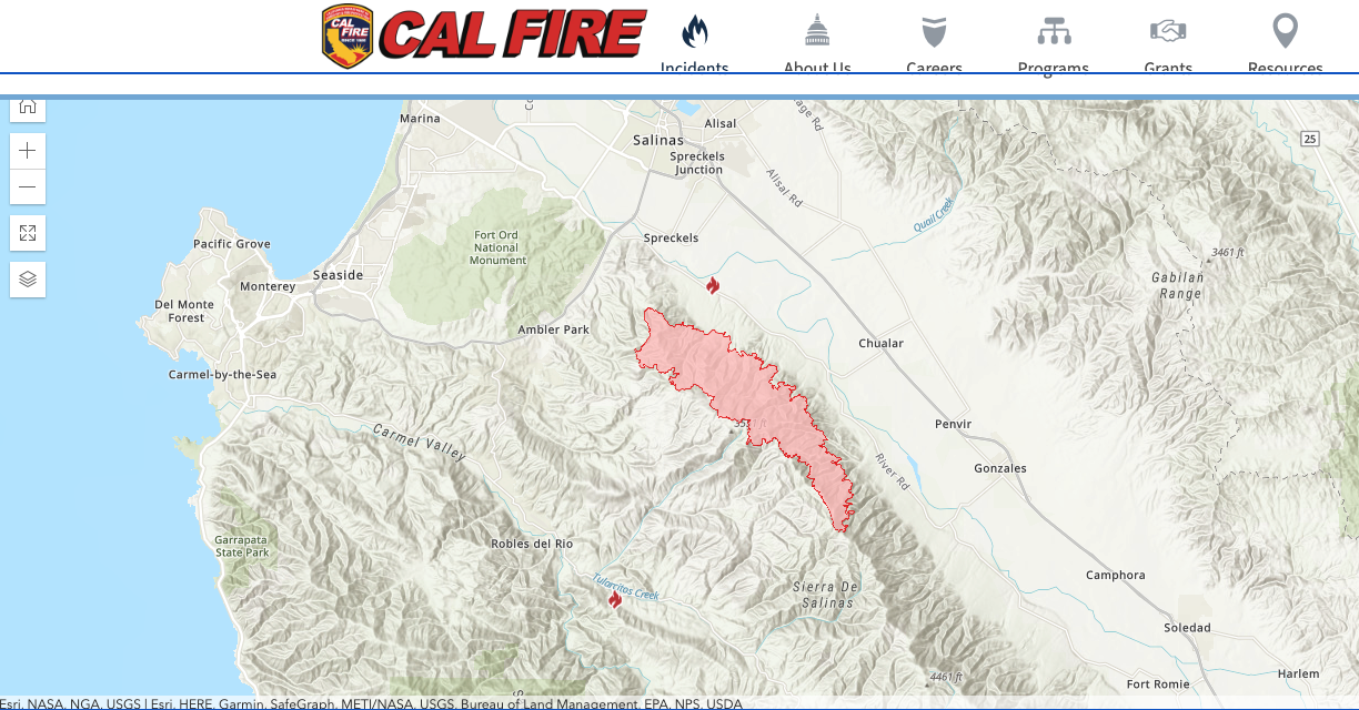
The River Fire burning near Salinas tripled in size on Wednesday, growing to 33,653 acres, according to Cal Fire.
It’s the fourth-largest fire of 26 burning in the state, according to Cal Fire’s incident page, behind the SCU Lightning Complex at 137,475 acres (5 percent containment), LNU Lightning Complex at 131,000 acres (0 percent containment) and CZU August at 40,000 acres (0 percent containment). The complex designation indicates multiple fires burning near to one another.
At least 367 fires, mostly in Northern California, were sparked by Sunday’s lightning — more than 10,800 strikes, Cal Fire said Wednesday.
Gov. Gavin Newsom declared a statewide emergency Tuesday due to the severity of the fires burning across the state. The declaration triggers additional resources to fight the fires.

“We are deploying every resource available to keep communities safe as California battles fires across the state during these extreme conditions,” Gov. Newsom said Tuesday. “California and its federal and local partners are working in lockstep to meet the challenge and remain vigilant in the face of continued dangerous weather conditions.”
AIR QUALITY
SCU and CZU August are burning near San Jose and Santa Cruz and the smoke from these and the River fires are contributing to the poor air quality in San Luis Obispo County.
An air quality alert issued by the San Luis Obispo County Air Pollution Control District and the County Public Health Department remains in effect for the third day.
An excessive heat warning and heat advisory remain in effect Thursday for the Central Coast as temperatures are expected to be in the triple digits for North County. The high-pressure system that has sat over the region was expected to shift east and bring lower temperatures Friday.
The air quality condition for Thursday was “very unhealthy” for Atascadero and was “unhealthy” for the remainder of the County.
According to the Air Pollution Control District, the air quality alert will remain in effect until there is a significant reduction of smoke in the air.
Air District officials recommend that if you smell smoke or see ash, take precautions, and use common sense to reduce exposure to smoke. All adults and children should:
- Head indoors and remain indoors, if possible
- Avoid strenuous outdoor activity
- Close all windows and doors that lead outside to prevent bringing additional smoke inside
To receive up-to-the-minute information on current air quality conditions, visit the San Luis Obispo Air Pollution Control District website at slocleanair.org
RIVER FIRE
Status:
The River Fire is 7 percent contained and has been burning since about 3 p.m. on Aug. 16.
The fire continued to be pushed by wind and burn in all directions. Firefighters continued their aggressive attack on the fire from the ground and the air. High temperatures, low humidity, topography influenced winds and steep mountainous terrain hamper firefighting efforts.
Evacuation Orders:
• Pine Canyon Road, Parker Road, Laurel Lane, and Trimble Hill Lane.
• West of River Road to Parker Road, South to Limekiln Road to include Limekiln Road.
• Southwest of Parker Road, northwest of Corral De Cielo Road, and Rana Creek.
• Southwest of the intersection Chualar River Road, and River Road.
• Northwest of Limekiln Road/Creek.
• West of river Road from Limekiln Road to Gonzales River Road.
• All areas south of Highway 68, east of San Benancio Road to include San Benancio Road south to Harper Canyon Road.
• Harper Canyon area, all areas north of San Benancio Road, west of Troy Lane, southeast of Harper Canyon Road, includes Harper Canyon Road, Weather Rock Way, and Rimrock Canyon Road.
• South of River Road from Tara Drive to Pine Canyon Road to include all roads off Las Palmas Parkway, Ranchito Drive, Indian Springs Road, Berry Drive, Enos Drive, Redding Drive, and Belmont Circle.
• Southeast of the intersection of Chualar River Road and River Road, northwest of Limekiln.
• Harper Canyon Area, all areas north of San Benancio Road, west of Troy Lane, southeast of Harper Canyon Road, includes Harper Canyon Road, Weather Rock Way, and Rimrock Canyon Road.
• All areas south within the intersection of Highway 68 and River Road to Tara Drive and Highway 68 south to San Benancio Road, including the Los Palmas 1 and 117 Drive Communities. This order does not include the Toro Regional Main Park area.
Evacuation Warnings:
• Indian Canyon, Mt. Toro Access Road and San Benancio Road from Troy Lane to Corral de Tierra, including Corral del Cielo Road, Lucie Lane, and Covie Lane.
• Areas North of Highway 68 from Portola Drive and Veronica Drive/Estoque Place east, to include all roads off of Portola Drive to Creekside Court.
• West of River Road extending west to Carmel Valley Road
West of River Road south from Gonzales River Road to Puma Road
• East of Carmel Valley Road from south of Tassajara Road to Finch Creek
Evacuation center:
• Monterey County, in collaboration with the American Red Cross, is offering both an evacuation center and evacuation shelter to meet the needs of fire evacuees.
An evacuation shelter is open at Carmel Middle School in Carmel. The shelter will be open 24 hours, can provide meals and sleeping accommodations for up to 20 people and can be expanded as needed. The SPCA is not currently on-site at this location. Carmel Middle School, 4380 Carmel Valley Rd. Carmel
• An evacuation center is located at Weather Tech Raceway Laguna Seca on Highway 68. The center is open 8 a.m. to 8 p.m. and offers evacuees water, snacks and a rest stop to make further plans or find out about assistance offered by the American Red Cross. Weather Tech Raceway Laguna Seca, 1021 Highway 68, Salinas
Road closures:
• Pine Canyon at Mesa Road
• River Road at Parker Road
• Indian Springs Rd at Murietta Road
• Los Palamas Rd at River Road
• Riverview Crt at River Road
• 117 Drive at Highway 68
Animal evacuation centers:
• Call SPCA Monterey County at 831-264-5455